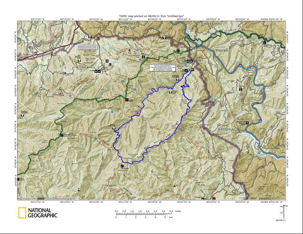
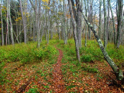
A daunting yet beautiful climb up Gunter Fork turns hairy when I stumble across a trio of fresh landslides, causing me to change my plans on the fly. Instead of an up and back hike, I circled around to Mount Sterling and back down to Big Creek. The deep green waters of Midnight Hole were very appealing to jump in. I would look to take a dip on the return trip when it would get super hot. Here's a look at the location of Midnight Hole in relation to the waters of Big Creek. 
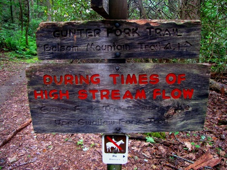
Gunter Fork is the only trail in the park that possesses such a sign, and for good reason. The deepest crossing was the first at Big Creek, with water rising above my knees. And that was with streams at low water. This picture is one of many crossings of Gunter Fork, one of the easier ones at that. Some were over boulder fields, others through log jams, and a few required tip-toeing the edges of small waterfalls. 
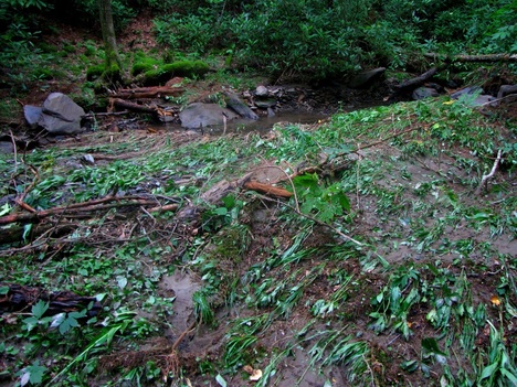
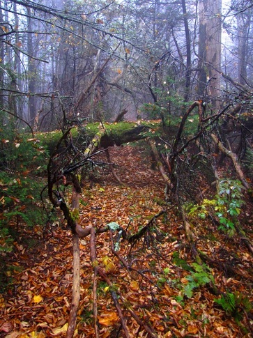
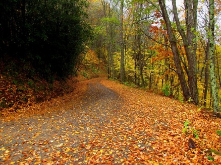
For much of the way the trail follows its namesake stream. There was a great deal of evidence of recent flash floods with Gunter Fork overriding its banks to flood the trail and low lying areas. 
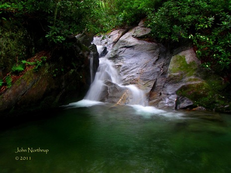
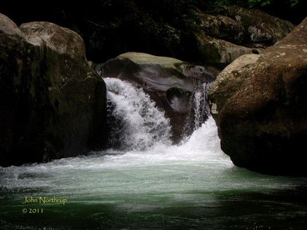
About 100 feet below the trail sits a magnificent pool along Gunter Fork fed by a peaceful cascade. The pool is deeper, more serene, and obviously more isolated than the very popular Midnight Hole. 
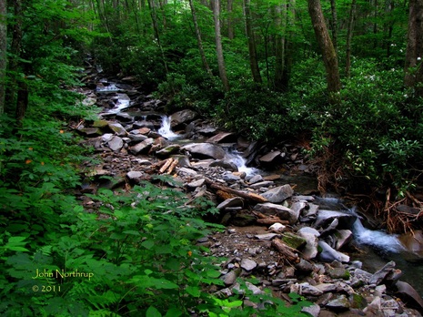
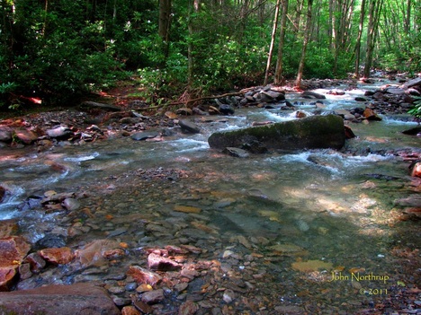
This is Gunter Fork at low levels, but you can see much more ground it covers after heavy rains and snow melts. To say it's a beast of a stream would be an understatement. 
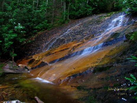
Standing at the base of Gunter Fork Cascade which sits before the last of the stream crossings. At this point it was starting to sprinkle, and with all the signs of recent and potential flooding, I was beginning to wonder if I wanted to come back this way. Here's a look up at the tall expanse of Gunter Fork Cascade. 
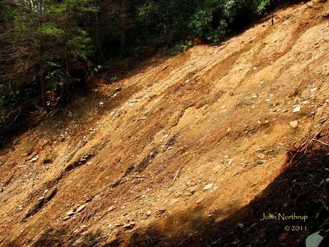
Everything changed about a half mile before the junction with Balsam Mountain. I stumbled upon a massive landslide that wiped out the trail and the rest of the major drainage. From what I could gather, it was a recent slide that probably happened within the last week due to the great deal of rain we've been getting. There were no signs along the way giving hikers warning, so it was safe to assume the park service knew nothing about it, and the I was the first to discover it. To try and go directly across the slide to reach the trail was impossible because the dirt pack was as slick as ice. 
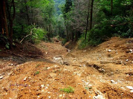
This is the view from trail's edge looking directly down the slide. The drainage wraps around the corner so I couldn't tell exactly where the massive pile up of dirt, rock, and trees would be. I had to weigh my options. Since I had to come ten miles just to get here, and only had a half mile to go, I began to look for a way up and around the slide. Where the earth gave way was but a hundred feet above the trail, but it didn't go all the way to the top of the ridge. So I deliberated one last time about turning around, then decided to bushwack my way up to the ridge, across, then back down through some of the thickest rhododendron you ever did see. I took me about forty five minutes to complete. It wasn't the most pleasant bushwack I've ever done, and it cost me the screen of my phone. Oops. I dusted off, gathered my thoughts, then pressed on. Amazingly, I came across a second slide, this one about fifteen yards across. It was as steep and fresh as the first, but there were more rocks sticking out of the earth to offer good footholds. I made it halfway out before I had to turn up the slide then bushwack down through the woods. Guess what? The fun didn't stop there, because I came to find yet another slide. This one being the smallest of the three at all but ten yards across. It was much broader and was an easy walk straight across. I finally arrived at the junction with Balsam Mountain in a daze of frustration and exhaustion. I ate some food and sat down for a bit thinking the situation over. There was no way I was going back that way to Big Creek, so I chose to add a few more miles and circle around Mount Sterling Ridge and down Baxter Creek. It lengthened my day but I knew it would be safer, especially if rain was in the forecast. Apart from the slides, Gunter Fork was overgrown with nettles and other thorny tangles that clawed me up. The trail was eroding in places, and there were numerous blowdowns. My suggestion to the park service as soon as I could reach them would be to close the trail for sure. 
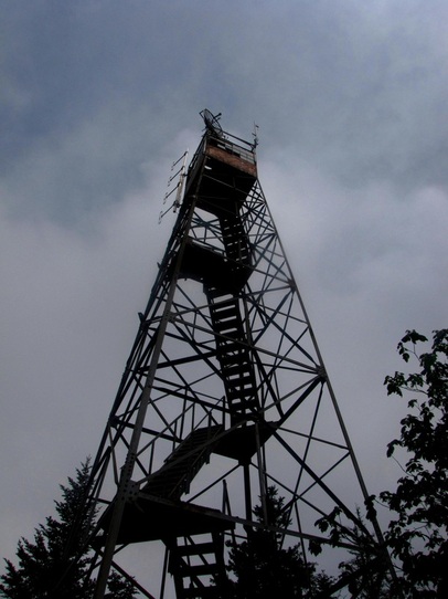
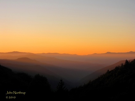
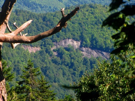
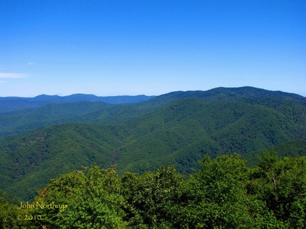
It took a while, and was not where I was expecting to end up today, but I made a trip to Mount Sterling none the less. Not much in the way of views, but it felt nice to sit up top and feel the cool breeze and relax. I needed it after a day like that.
0 Comments
I had to admit, the weather for this week was looking phenomenal. I already had two great days in the park soaking up grand views and fantastic fall foliage. Today was calling for some clouds and rain throughout the morning and early afternoon, but even then it was going to clear off. On top of that, the next two days were looking great as well. No room to complain this week! It's such a great time of year to be in the park, so even with the unfavorable weather conditions today, I still wanted to get something out of it. I also wanted to be able to cover all corners of the park while the changing colors were at their peak. My instincts told me to take the drive across the park, east on the Blue Ridge Parkway, and make my way up, down, and around the one-way Balsam Mountain Road. I would also get in a few short hikes along the way, just to wet my whistle. The rain that night had done a bad number on the upper elevations around Newfound Gap. Whatever leaves were clinging to the trees before it came were now ripped off with authority. There weren't any views from the various overlooks traveling through the park either. Down lower, the colors were still in decent shape, just a little soggy. As I made my way up the Blue Ridge Parkway, I managed to find one overlook with a view beneath the clouds. I could see the slopes extending from the Balsam Mountain range with patches of color. I also took notice of the fine color display in my immediate vicinity. Now, the last time I made the drive along Balsam Mountain, it resulted in a great deal of frustration. I made sure to check both online and over the phone to find out if the road would idneed be open upon my arrival. Sure enough, the gate was wide open and inviting. The clouds still socked everything in, so there were no views at the moment. I didn't mind because the rain had ceased along with the wind. It was actually a neat experience to drive along a high mountain road through the clouds. The unpaved road was blanketed in shades of yellow and orange from the recently battered foliage. A ways out, I came to the pull-off for the Spruce Mountain Trail. The park recognizes and maintains but a half mile of this trail. There used to be a firetower at its summit, but the path to get there has been left to nature. It also connects to the northern end of the Polls Gap Trail at a campsite, but that too is closed because of blowdowns and erosion. As short as this trail is, it doesn't shy away from gaining a chunk of elevation. About halfway up, I came to a point where the forest was in transition from summer to fall. If I looked downhill, the vegetation was entirely green and the path muddy. When I did a 180 degree turn and lookedu phill, the trees were suddenly bright with yellow and the ground was covered in a collage of colors. It was such a sharp and unique contrast in that one small pocket of the woods. When I scaled the ridge, there were a few junctions, the first one leading left and uphill to the old tower. I needed to at least go to the campsite which was a few tenths further. Before arriving there, I passed a sign describing the status of the Polls Gap Trail. Needless to say, my surroundings gave merit to the trail's closure because massive were down and tangled everywhere. It looked like a war zone to be honest. From what I could see, there were dozens of blowdowns and dense brush overtaking the forgotten trail. After visiting the campsite, I was interested in taking the old path up to the summit. There was a large blowdown at that junction as well, blocking the turn, but I could see past it and the trail was obvious. I was intrigued, so I decided to follow it. There was a lot of crawling, climbing, pushing, and pulling through all of the trees and saplings. By the end, I was drenched because of the rainwater sticking to the leaves. Through it all, I never lost site of the trail. I eventually reached the summit, looked around, and headed back. It would be neat if there was still a tower here to offer rare views into this area of the park. It was nice to reach the maintained trail and no longer have to fight through obstructions. When I returned to the road, I looked around first and admired the scenery and enjoyed the solitude. I dried off before hopping back into the vehicle, then continued north along the one-way road. Along the way, the clouds were beginning to break and sunlight was passing through the gaps intermittently. It appeared the day was about to get a whole lot better. I reached the trailhead of Balsam Mountain Trail, the very spot I was hoping to begin back in early September. So I had a 2.3 mile stretch to do, and with the weather improving, I was very excited to see it through. There is a bit of elevation gain this way to Beech Gap, but not nearly as much as coming up from Round Bottom along the gap's namesake trail. The forest canopy was bare for the most part, but every so often I would look up and find a big beauty. One that really stood out was loaded with bright red leaves near Ledge Bald. At that point the clouds had all but dissipated. The sun was high and bright, and the blue sky served as a sweet backdrop for the lingering fall color. The trail continues to scale the gently sloping ridge of Ledge Bald. With all of the trees stripped of their leaves, the area appeared very open. A lot of light was shining in now, like it would in April and May when wildflowers bloom along the ground but the trees are yet to fill in. You could catch glimpses of nearby ridges and peaks through the trees. The entire bald on down to Beech Gap was covered thick in white snakeroot. It was no longer blooming, but I remember what it looked like at that very gap a month and half ago. You had to fight through it at points because it grew in so thick. Ledge Bald is rather extensive as it twists around the spine of Balsam Mountain. Not nearly as famous as the park's other maintained balds, but I still found it special. After the bald, the trail drops rapidly into Beech Gap. You lose the views and find yourself surrounded by more firs than before. I had filled in this gap on the map, so I didn't need to go any further. I reminisced for a moment then turned right around. The weather continued to improve the rest of the way. I made it back to my vehicle and would spend the rest of the afternoon driving around. My hiking for the day was done. I followed the one-way road down toward Straight Fork and out toward Cherokee. Another corner of the park seen and thoroughly enjoyed this autumn.
Journal about nearly 21 mile escapade across the Balsam Mountain range from Round Bottom to Tricorner Knob coming soon! Catching sunrise from Luftee Gap along Newfound Gap Road. Morning at the unchanged Laurel Gap Shelter. Interesting mountain side of smooth rock, a rare sighting in the Smokies. Inside the already refurbished Tricorner Knob Shelter for the first time in 5 years. Miles and miles and miles and miles of these trees....hence named Balsam Mountain.
Of the various construction projects going on around the park, one I had been eagerly awaiting completion was that along Balsam Mountain Road. My last visit to that area was only as far as the auto-gate just past the Hemphill Bald trailhead. That was back in July while construction was still being done along the roadway and Balsam Mountain campground. Since I was about to drive a ways, I checked the morning I left to ensure that the road was indeed open, and not just the paved section, but the gravel one-way portion that wraps back around to Cherokee as well. According to the park hotline and website, the roads were open, so I got an early start and hit the highway. To say the weather conditions were stellar would be an understatement. The skies were crystal clear for the first time in a long time, enabling one to see to the horizon and beyond. There wasn't a cloud in the sky and the temperature was comfortable. The excitement was building because I knew my entire hike would see me navigating the upper elevations along the lengthy ridge that is Balsam Mountain. I couldn't wait to arrive at the trailhead, but the action started well before I got there. If you're someone whose driven across the park from Gatlinburg to Cherokee, you know that prior to reaching the Oconaluftee Visitor Center, there are a number of flat open fields on either side of the road. Well in passing through these fields, there was traffic congestion and people getting out of vehicles with cameras. I found it unusual for I had never experienced any car-jams in this area. I had also never seen in the Smokies what I was just about to see. A HERD OF ELK!!! To my left were a number of cows and calves, but the one that stood out among the crowd was the massive bull. To finally see one in the park was incredible. I slowed down, making sure not run over some unattentive tourist, and to allow myself a brief moment to enjoy the animals. The bull, majestic and statuesque with its impressive spread of antlers, was actually the closest to the highway. The timing was all but a few seconds but it lingered for an eternity. I was smiling in such disbelief for much of my remaining drive. The trip along the Blue Ridge Parkway was exhilarating as always with its numerous overlooks. Another surprise came about shortly after leaving the parkway while on Heintooga Ridge Road. Beside the road on the driver's side were yet more elk! This time it was a mother and her spotted calf grazing. The cow seemed unaffected while the calf trotted closer to the woods and away from my daunting vehicle. Since this time the setting was much more intimate and I didn't have to contend with other gaukers or traffic, I was able to say hello and snap a few pictures. The day just kept getting better, and here I hadn't even started hiking yet. In continuing my drive north, I made it past the parking lot at Polls Gap and through the gate shortly after, now open to traffic. The construction vehicles that were here a few months prior had moved on. The road was newly paved making for a pleasant drive. The campground, which had also seen improvements, was open as well with large campers filing in and out. Just after that the paved road makes a wide turnaround for vehicles looking to remain on the two-way portion. There was also a vast collection of construction vehicles, which kind of had me worried. Sure enough when I started to make my way onto the gravel one-way Balsam Mountain Road, everything changed. The gate was closed to all vehicular traffic. Talk about a slap in the face, punch to the stomach, whatever you want to call it. I was so frustrated and dumbfounded at this. I stepped outside and approached the gate with wishful thinking that maybe it was loose and just swung closed accidentally. That clearly was not the case as I came to find a piece of paper taped to the middle. It stated that the one-way road was temporarily closed for renovations...starting date...today! I was livid to say the least. And this was after I had checked both the park hotline and website in regards to road conditions before I left, neither of which mentioned this closure. And one would think that even though it neither said it was currently closed, there would have been some statement alerting visitors about an upcoming road closure. That way people could have been notified and planned accordingly, before driving an hour and a half across the park in order to find out. I was furious! And with gas prices as ridiculous as they are, I wanted to storm into park headquarters and demand $20 back or something for this debacle. Yes, I understand that the timing was as close as it could be, but the fact that neither resource for road conditions provided any warning for visitors in advance of the closure. That was what frustrated me the most. And here it was, just an amazingly beautiful day for a hike, literally stripped away from me. I stomped around creating potholes with each step, burning holes in things with glaring eyes, steam coming out of my ears, and some choice words spilling out of my lips. I wanted to scream at the top of lungs because it was going to be such an incredible day. I eventually collected myself, pulled out my map and began to look for alternatives. I began looking for something close by because I didn't want to feel like I had wasted an entire day just to drive out here and turn back. The closest and most viable option was the Flat Creek Trail, for it began at the paved road turnaround. I went back and forth in my mind as to whether I should do it or save it, eventually choosing to just go ahead and get it done. It was going to be much less than what I was anticipating to do today in terms of miles...about 15 miles less. So I grabbed my pack and my camera, tightened up the boots, took a deep breath, and got started. Right where I parked my car there were heart leaved asters, filmy angelica, and white snakeroot in abundance. Not but a few yards beyond the trailhead was a grand overlook with benches beside the trail. I had to admit, in all that just transpired, this view took off some of the edge. There in front of me, as far as the eye could see, endless rides of deep greens and blues, in great definition due to the clear air. In addition to the clear blue sky, it made for an impressive sight for summer, with views much clearer than one would see in June and July. The expanse of mountains went as far west as Clingmans Dome and as far east as Mt. Guyot. I could pick out ever notable point along the Smokies main crest and the Appalachian Trail. I took several pictures, panoramics, and even a video. Now it was time to burn off some steam. Past the overlook, the trail continues downhill along the broad western slope of Balsam Mountain. It eventually cuts inward along the mountain top, but since it's so large, it seems like you're walking through an open meadow down in a valley. The terrain is very flat, there are numerous stream crossings via rock hop and foot bridges, and the woods are very open and grassy. Evidence of the mountain's logging history. The scene reminded me of one my favorite destinations in Spence Field. At one footbridge, there was a large collection of pink turtleheads in full bloom. This was exciting because I hadn't seen many of them in bloom away from Mt. LeConte and its six trails. What was also interesting was the variety of color. Some blooms were a dark pink, a light pink as pictured below, and a few in solid white. Shortly thereafter, I came to a place where a trail sign was off to my right in overgrown brush. It provided distances to the trailheads in either direction, but nothing else. Surely a sign situated in the middle of the woods would mark something of importance, like at an intersection with another trail, or a spur to an overlook or waterfall. I figured I would check it out on my return trip. Continuing on I came to a fun rock hop. What made it so neat were the leaves floating down the stream and sitting on the rocks. Here it was the last day of August, still in the throws of summer, and there were already leaves falling and changing color. A number of the leaves that were sitting in the shallow parts of Flat Creek had a shiny, metallic appearance. In several places there were large stands of yellow and orange jewelweed in bloom. I remembered seeing them in droves beside the roadway as well. After the last footbridge, the trail swings up hill, and steeply in places, as it makes its climb back to the paved road. If you aren't looking for this end of the trail when you drive by, you'll surely miss it as I did. But it's located somewhere between Poll's and Black Camp Gaps. When I reached the road, I looked around, took some pics, watched a car pass, then turned right around to head back. Again, the rock hops and pleasant meadow walking was a treat. When I made it back to the peculiar sign, I did some more exploring. Sure enough, the overgrowth had obstructed the path leading away from the main trail and downhill toward a ravine. I elected to follow for a few tenths, curious to see where I would end up. Sure enough, I could hear the sounds of rushing water grow louder as I got closer. Then the path took several forks, one down to the right and another straight and then way down. I took the first, and after climbing over some roots and branches, I came out at the top of a long cascade. I read later that this was indeed the Flat Creek Falls. To be honest it was more like a shute, since the water was moving so fast through a narrow space between the rocks. It was also very steep for I could see all the way down to the bottom. I went back up to the path and took the other way to the base of the falls. I probably could've done without this, because the trail disappeared and there wasn't a whole lot to see where I ended up. Making my way down entailed clinging on to trees, roots, exposed rock, and if I couldn't find any, it meant having to slide down smooth rock faces on my rear end. There further down I went, the more I dreaded the trip I would have to make back up. When I came to a flat spot beside the falls, there just wasn't anyway to get a picture of the entire falls. It was too overgrown with rhododendron and the ravine was so narrow. So with careful foot placement and patience, I made my way back up to the path and the main trail. When I finished out the trail and arrived at my vehicle it was still morning, and I wanted to do some more hiking, especially since I had originally planned to put on over 20 miles today. So I looked at my map and saw that the Balsam Mountain Nature Trail was nearby. Yes it was very short, but it was something, so I gave it a go. In no time I took the path which comes out at the campground, looked around, turned back, passed a couple of people enjoying an easy hike, and I was done. I tried to make the most of what I could while I was there, but I was still livid over the one-way road being closed. So I made my way back to Gatlinburg, taking my time to at least stop at the various overlooks along the Blue Ridge Parkway and Newfound Gap Road. I was still in awe at how spectacular the views were, and so clear at that. One of my favorites would be the Mile High Overlook in which you can look out over the Balsam Mountain expanse as well as the main ridge of the Smokies. I still had tomorrow left to get in a good hike, and I still had my heart set on hiking the Balsam Mountain Trail to Tricorner Knob. Of course, with the road closure it would mean finding an alternative starting point. And I would have given anything to have another crystal clear day like this one. Whatever was going to happen, all I could do was sleep on it and hope for the best in the morning.
|
Thanks for visiting!I appreciate you stopping by. This site is for your enjoyment as much as it is mine. Look for new photos and journal entries about every 1-2 weeks. Archives
November 2011
Categories
All
|